
George M. Myers
RC Flying Today
70 Froehlich Farm Rd., Hicksville, NY 11801
Abstract
Where can I fly? LORAN letters.
Questions for newcomers
People entering our hobby today need answers to several important questions:
- Where can I go to fly?
- What should I know about the flying site?
- Where's the nearest hobby shop?
- Where can I find a good flight instructor?
When a beginning person first decides to take up RC flying, the most pressing need is information. People, magazines, and books provide it. The next need is for radio, engine, and plane. Depending on where the modeler lives, these may come from a local hobby shop or by mail. Most business goes by mail and the local hobby shop survives on bits and pieces — glue, fuel, props — whatever base business keeps the owner eating regularly.
A great day arrives when the newcomer is ready for the first flight. Now the most important question becomes obvious: where does one fly an RC airplane? The new flier can go to obvious open spaces — schoolyards, parks, athletic fields, beaches, etc. — only to be met with signs prohibiting such activities "under penalty of the law." Or the newcomer can go to a place where other people fly RC and be met with other problems, the first usually being, "Join the AMA — for the insurance." There's something wrong: the answer to the important question depends on where you live.
Examples from my travels:
- Preston, Idaho: the RC hobby shop was part of a farm machinery repair office, and we flew beside the active runway of a small airport.
- Long Island, New York: sites can be inside patterns for major airports. For example, one site at Floyd Bennett Field is shared with U.S. Coast Guard helicopters and lies inside the pattern for JFK International Airport.
- Provo, Utah (December 1981): we drove a few miles out of town to fly off a vacant lot in an industrial park next to I-15, one of the region's most active highways.
- South Bend, Indiana (1985): we had to drive about 20 miles into surrounding farm country to find a field; that site is now covered with tract housing.
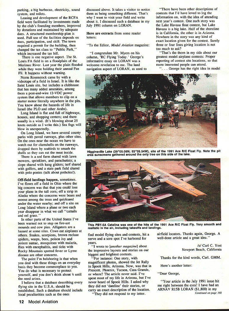
- St. Louis RC Flying Association (south St. Louis, Missouri): a well-developed club field with permanent worktables under a high roof, paved pit areas, taxiways and runway, steel safety fences, sodded perimeter, good parking, a big barbecue, electricity, sound system, and toilets.
Leasing and development of the RCFA field were facilitated by investments from the club's founding members, improved by donations, and maintained by adequate dues. A structured membership plan is used; full use of the facilities depends on dues, participation, and skill. The town required a permit for the building, then changed the tax class to "Public Park," which increased the tax bill. One negative aspect: the St. Louis field sits on the Meramec River floodplain. The plain flooded during the annual Fan Fly, sometimes without warning.
Norm Rosenstock brought a videotape of a field in Israel. It is similar to the St. Louis site but includes a clubhouse with many added amenities, among them a post-and-wire 12 VDC power system that allows members to clip on a starter motor anywhere in the pits. (Be aware of the hazards of life in Israel — the PLO and other tensions.)
Long Island is flat and dense with highways, houses, and shopping centers, and it is usually windy (it was blowing about 25 knots as I wrote). Sea fogs can roll in unexpectedly. On Long Island we have several county parks with paved runways and other sites. Sites near the ocean have special hazards — clamshells on runways dropped by seabirds that break shells to eat the meat inside. There is a sod farm shared with lawn mowers and sprinklers, a slope shared with hang gliders, turf shared with golfers, and a state park field shared with polo ponies (talk about potholes).
Off-field landings happen, sometimes
I've flown off a field in Ohio where the big concern was losing your plane in tall corn; off a strip in Alaska where concerns included bears and moose among the trees and quicksand near water; and off a site on Long Island where a plane or two each year disappears in the cattails and eelgrass. In other parts of the U.S. I've been warned about fire-ant mounds and cow pies. Alligators are a hazard at some sites; cows have been known to damage airplanes at others. Other local hazards include snakes, scorpions, brown recluse spiders, wasps, bees, poison ivy and poison sumac, mosquitoes carrying malaria, flies carrying encephalitis, and ticks carrying Rocky Mountain spotted fever or Lyme disease.
The point is that when you deal with these things on an everyday basis they become commonplace. You prepare to protect yourself before a problem arises and you don't think about it until necessary.
I believe a database describing every flying site in the U.S. should be established. Such a database should include local peculiarities like the ones discussed above. It takes a visitor to notice them as being something different. That's why I want to visit your field and write about it. I discussed such a database in my July 1991 column on LORAN.
Reader letters
Carl C. Yost — Newport Beach, California
To the Editor, Model Aviation magazine:
I congratulate Mr. Myers on his column, RC Flying Today. George's informative essay on LORAN was a welcome revelation to me. The land navigation aspect of LORAN, as used to...
There have been other descriptions of contests that I'd have loved to log the information on, with the idea of attending next year's contest. One such story was the Lake Havasu float contest, but Lake Havasu is a big lake. Half of the shoreline is in California, the other half is in Arizona. Nowhere in the story was any kind of exact location given for the contest. Surely three or four lines giving location is not too much to ask?
That's the thorn in my side about our greatest model airplane contests: proper reporting of contest site locations, so that more interested people can attend. George has the right idea in model airfield locators. Thanks again, George. A nerve and a sore spot I've harbored for years.
I wrote to [another magazine] about the impressive layouts and stories on our biggest and brightest contests. For instance: one story, with magnificent photos, showed the Jet Rally in Spook Hills, Arizona. Now, was that in Prescott, Phoenix, Tucson, Casa Grande, or where? The article never said. I've spent most of my life in Arizona, but I've never heard of Spook Hills. I asked why they did not "dateline" their stories, or carry an exact description of the location. They did not respond to my letter.
/s/ Carl C. Yost
James D. Campbell III, PE — Newark, Delaware
Dear George,
Your article in the July 1991 issue hit me right between the eyes! I have had an ARNAV R15B LORAN ($1,800) in my GMC Suburban.
None of the highway maps show lat/lon anymore. So I have used Geological Survey 7.5-minute-series charts (1:24,000) to locate precise degrees/minutes/seconds. The NOAA aviation sectional charts (1:500,000) and TCA charts (1:250,000) are adequate for locations in degrees/minutes. Precise locations of airports are given in the Airman's Information Manual (AIM), Jeppesen's air route manuals, and the AOPA Aviation U.S.A. manual.
I will now try to get AAA to put lat/lon on their maps and will alert the RV community to your concept.
encl: Reprints of LORAN and GPS articles.
/s/ James D. Campbell III, PE AMA 30606
From data supplied by Mr. Campbell, I learned that the FAA has commissioned two more LORAN chains to fill the midcontinent gap from just west of the Mississippi River to the intermountain West. A test receiver in Kentucky, monitored continuously for a year, showed a seasonal variation of indicated position of as much as 1,400 feet (a little more than 1/4 mile). In most situations that variation won't cause you to lose sight of the model flying site you're looking for, even if a database contained position numbers that were precisely correct only twice a year.
The GPS (global positioning system) was also discussed in Mr. Campbell's papers. GPS uses 21 satellites orbiting at about 10,000 miles altitude to give lat/lon and altitude by triangulation. The cost of receivers (then) ranged widely — $7,000 to $70,000 per receiver — and the accuracy was no better for our purposes.
I also saw a TV news broadcast extolling a new $4,000,000,000 Department of Transportation program to put "smart cars" on the streets of Chicago using GPS for navigation. The idea was that with large DOT funding, navigation systems (or LORAN receivers) could be put in many vehicles. You can buy a Ray Jefferson L-100 LORAN from a boat equipment store (about $250) and have a useful navigation aid right now. Four billion dollars could put LORAN in every car and truck in the U.S.
Thanks for the information, Jim. LORAN is very useful for returning to a campsite after dark, particularly if you didn't leave a trailer to mark the spot. I've used the L-100 from New York City to Keene, New Hampshire; to Chicago; to Kansas City; to Memphis; to Knoxville, Tennessee; to Washington, D.C.; and back to New York. It never got lost. — GMM.
A. J. Horner — Friday Harbor, Washington
Dear George,
I have enjoyed your columns over the years and thank you for your efforts. The July article on LORAN and the technical marvels of today has prompted this response. Interference problems arose when I lived in southern California in 1981–83, and I wrote a program in North Star BASIC and CBASIC to calculate distances between potential interferers and flying sites. You can see how the program could be used for your database.
Your idea of having the location of all available flying sites in a database on Compuserve is great. Keep up the good work. Feel free to contact me by mail, as I have dropped out of Compuserve because it costs me as much to reach Compuserve as the connect time on Compuserve.
/s/ A.J. Horner AMA 65568
Mr. Horner's correspondence included his 1983 response to a July 1981 request by Dave Brown (then AMA District III VP) for a lat/lon distance computer program to evaluate potential interference in the 50-channel RC raster. It appears some of this work was forwarded to AMA HQ where it did not progress. Mr. Horner invested a month of 10-hour days into the programming and stands ready to continue the effort.
Mr. Horner's comment about dropping out of Compuserve exposes a problem: not everyone has access to Compuserve. If AMA were to set up a database for flying sites, members' access could be handled another way. Rather than hosting the database on Compuserve, AMA could put it on an RBBS (remotely controlled bulletin board service) using a modest desktop computer and a dedicated telephone line. If usage justified it, the line could become an 800-number, eliminating access costs to members. Funding for running the service could come from a small subscription fee, ads, or donations.
Tim Smith — Bennington, Vermont
Dear George,
Our club, the Hoosic Aeromodellers, had about four crashes in one day... A week later, we found out that a newly formed club had started up on a farm about one mile away (as the bird flies). If your idea had been implemented, this new club could have known our whereabouts before they flew. I wish you good luck in your attempt to get AMA to make it mandatory to register each club's lat/lon.
/s/ Tim Smith
Closed membership rolls and "secret" fields cause more problems than they cure. We had a problem on Long Island with airplanes getting shot down at a "club members only" site. It turned out students at an adjoining college were flying helicopters (with college permission) over a nearby athletic field. Which is worse: getting shot down at your "secret field" by someone at an open field, or getting shot down at your club field by someone from a "secret field"? Open membership gives you the opportunity to teach people about the hobby and its responsibilities. If someone flying alone causes an accident that gets your site closed, having them join your club gives you a measure of control: once they've paid dues they have something to lose if they break the rules, and you get a chance to tell them the rules and why.
RC Flying Today — Notes and Announcements
Did you read the "Nitro Panic" inserts in the August AMA News and Focus on Competition sections? I recently watched an ESPN report about the May 1991 blowup of Louisiana's Angus plant, a source of much of the world's nitromethane. Other suppliers are filling in as best they can. Full production was anticipated to be restored in late 1992. If the cost of nitro rises, expect the price of glow fuel to increase and remain higher. Perhaps this is a good time to investigate the beauties of electric-powered flight.
George M. Myers RC Flying Today 70 Froehlich Farm Rd. Hicksville, NY 11801
Flying-site notes and coordinates
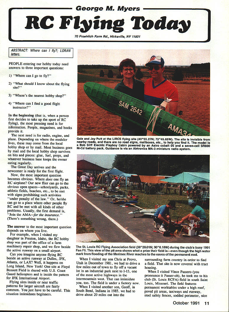
- Gale Jay Putt — LIRCS flying site
40°05'27"N 72°04'58"W — site hard to find; nearby roads have no road signs or mailboxes to help locate the field.
- Bob Sliff — Electric Playboy Cabin powered by Astro Cobalt .049; seven-cell SR800 Ni-Cd battery pack. Guidance via Airtronics MA-3 miniature radio system.
- St. Louis RC Flying Association field
38°02'01"N 90°08'18"W — during the club's busy 1991 Fan Fly the pit area showed what a prize field it is, even though the high water mark from Meramec River flooding reaches the eaves of the permanent roof. Parking, big barbecue, electricity, sound system, and toilets. Leasing and development were facilitated by founding-member investments, donations, and adequate dues under a structured membership plan. Full use depends on dues, participation, and skill. Town-required permits and a tax-class change to "public park" increased the tax bill. Warning: the field is on a floodplain and can flood unexpectedly.
Warning: When you call or write your district VP, be courteous. Even though the VP is an elected officer, he is a dedicated volunteer and not paid to serve you.
Transcribed from original scans by AI. Minor OCR errors may remain.

