
George M. Myers 70 Froehlich Farm Road, Hicksville, NY 11801
RC Flying Today
Solving the three-mile problem
You can't do much RC flying today without insurance. Site owners demand insurance.
You may have noticed that the AMA Safety Code states, "I will not knowingly operate an RC system within three miles of a pre-existing model club flying site without a frequency sharing agreement with that club."
AMA Frequency Committee members George Steiner and Bill Hershberger carefully measured the strength of RC transmitter signals over flat ground and measured the responses of modern narrow-band RC receivers to determine the minimum safe distance under their conditions. The AMA Executive Council adopted their recommendations and amended the Safety Code. You must follow the Safety Code to have the protection of AMA insurance. How do you do that? How do you measure the distance?
In flat country, you might drive your car between two sites and let the odometer do the measuring. An intervening river may present a problem. If you can't drive in a straight line, you may have to work some geometry on a road map (obtainable from gas stations and bookstores).
Road maps are intentionally simplified in small details (for example, road spacing may be shown wider than actual) to present a clearer picture. You might prefer a more accurate U.S. Coast and Geodetic Survey map, available from outdoors stores that cater to hikers. Or you could buy a Sectional Chart from the Fixed Base Operator at any small airport. Sectionals are accurately gridded in latitude and longitude (lat/lon), within the limits of conical projection. Whichever map you choose, get the smallest available scale, set your compass to a three-mile radius, put the point on your flying site, then draw a six-mile-diameter circle. Nobody else should have a flying site that is in use at the same time inside that circle. Let the arguments begin!
The AMA Executive Council also decided that if two clubs must fly from sites closer than three miles apart, they must file a compatible Spectrum Use Plan with AMA in order to renew their charter.
Executive Director's note
Due to topography or other factors, clubs may be operating safely with less than three miles' separation of flying sites. If, after testing, this condition exists, all that is required is a statement between the clubs that the testing was accomplished and no interference potential exists. It is suggested that a copy be provided to AMA for filing in the respective clubs' 1994 files. This is in lieu of specific frequency-use plans.
One feasible plan is odd channel numbers at one field and even channel numbers at another. You can figure out others. Bear in mind that any field that buys our club insurance will be part of the AMA insurance, too.
Latitude/longitude, LORAN and GPS
The universal way to specify locations and measure distances is by lat/lon. LORAN tells me where I am, which way to go to reach my destination, speed now, time to go (at speed now), distance to go, magnetic compass heading, and bearing to the destination. It also calculates distance between any two locations.
The Global Positioning System (GPS) was completed on June 26, 1992, ending a 35-year effort. GPS receivers display lat/lon and do many of the same things as LORAN, but at greater cost and no improvement in accuracy for civilian use.
Each of the 24 satellites emits two signals: one for civilians and the other for the U.S. military. The U.S. government degrades the civilian signal to limit precision (position numbers repeatable within about 60 feet on a given day, and within about 1/4 mile over a year). Military GPS systems can read the encrypted code to get better precision.
When you want to make use of LORAN or GPS, you need a LORAN or GPS receiver and a map marked in lat/lon. If you have a computer, one way to get such a map is to use the Automap program, which makes maps with lat/lon grids. Just point to something on the screen to get its lat/lon.
Mapping software and techniques
Automap navigates between cities and villages on interstate and U.S. highways. It can print maps and detailed itineraries between cities, giving road names, elapsed time and distance to intersections, plus steering directions (for example, "go 50 miles west on I-80, head toward Columbus, Ohio"). You can use Automap's distance function to measure distances between flying sites, right on the computer screen.
When you want more detail, use MapExpert 2.0 (requires a CD-ROM drive). MapExpert 2.0 shows every road in the U.S. (as of its map date). You can search by lat/lon, village name, ZIP code, or telephone area code and exchange; MapExpert shows the area and can be centered on a street name and block number. MapExpert highlights the street and thus shows what side of the street an address is on, provided it was charted before 1990.
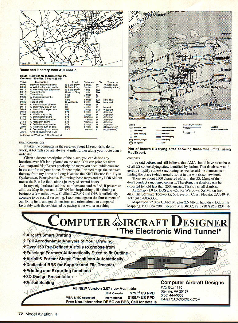
MapExpert also has Lat/Lon grid, Draw, and Distance functions. You can spot airports and draw three-mile-limit circles on the screen.
While on the subject of map circles, most off-field landings occur at the end of the runway—practically all of them within 1,000 feet of the flight line, and for large airplanes and extreme ranges within 2,000 feet of the flying site. You might want to draw those circles on the map to see what's at risk.
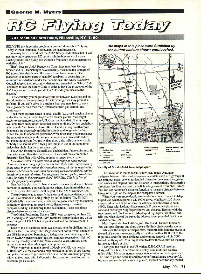
Given a decent description of a place, you can define any location even if it isn't plotted on the map. You can print precisely the maps you need while in the comfort of your home. For example, I printed maps that showed the way from my home on Long Island to the KRC Electric Fun-Fly in Quakertown, Pennsylvania. Following those maps and my LORAN put me on the Buc-Le field after a journey of several hours.
In my neighborhood, address numbers are hard to find, if present at all. I use MapExpert and LORAN for simple things like finding a business a few miles away. Civilian LORAN and GPS are sufficiently accurate to do casual surveying. I took readings on the four corners of our flying field and got dimensions and orientation that compared favorably with those obtained by pacing it out with a marching compass.
I've said before, and still believe, that AMA should have a database of all U.S. contest flying sites identified by lat/lon. That database would greatly simplify contest sanctioning and help contestants find locations, which usually are out in the woods somewhere.
There are about 2,500 chartered clubs in the U.S. Many of them don't conduct sanctioned contests. Therefore, the database can be expected to hold fewer than 2,500 entries. That's a small database.
Navigation hardware note
I navigate the roads in the U.S. with a $250 LORAN receiver designed for a boat. The display is in knots and nautical miles. Add 15% to the number to get statute miles and miles per hour. The time-to-go, heading, and bearing information are most useful because you see the situation at a glance without mental math conversions. It takes the computer in the receiver about 15 seconds to do its work; at 60 mph you are always about 1/4 mile further along your route than is indicated.
Recommendations and resources
- Consider odd/even channel schemes or other compatible Spectrum Use Plans when fields are closer than three miles.
- Use lat/lon and LORAN/GPS for precise site identification and for creating a club or AMA database of flying sites.
- Draw three-mile circles (and smaller circles for likely off-field landings) on maps to visualize potential conflicts and risks.
Software and vendors:
- Automap v1.0 for DOS and v2.0 for Windows. Requires 5.8 MB hard disk. The Software Toolworks, 60 Leveroni Court, Novato, CA 94949; Tel.: (415) 883-3000.
- MapExpert v2.0 on CD-ROM, plus 2.6 MB on hard disk. DeLorme Mapping, P.O. Box 298, Freeport, ME 04032; Tel.: (207) 865-1234.
Transcribed from original scans by AI. Minor OCR errors may remain.

